Day 8 - 01/09/2008 - Germany and Belgium.
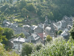
Monschau, Germany.
Day 8
We got up reasonably early and took a drive around the Hürtgenwald. This area was the scene of ferocious fighting in the forests which had been planted on the German frontier to provide a natural obstacle. Whole divisions disappeared into the hell of the forest in this small area which was vigorously defended by the Germans.
Drove to the small town of Bend to get a “Then and Now” comparison photo passing through Paustenbach and getting a good photo of some Dragons Teeth which were part of the Westwall defenses and were anti-tank obstacles. We drove to Vossenack where the legendary Kall Trail of the battle starts. Had a lovely chat with the owner of a bakery in town who enjoyed practicing his English with us. When I showed him a photo of the church damged in 1944 he said he remembered the Americans being there and all the trucks, tanks and soldiers. He looked a bit sad and said “Alles Nicht…kaput” meaning “All gone…destroyed” referring to the town of Vossenack . Went to the local German war cemetery and had a look around. There was a man on a ride on mower and he saw me looking around and asked “Model?” I replied “yes” as I was looking for the grave of Generalfeldmarschall Walter Model. He pointed me in the right direction.
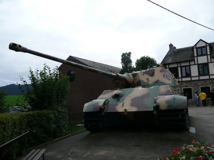
From here we drove back through the forest to the Monschau Valley and went to the town. Another picture postcard perfect German town. Alas the Felsenkeller brewery museum was not open. At an indoor craft area we bought Liam a rattle and the stall owner engraved his name on it. Had Coffee and cake and headed off to drive through the Battle of the Bulge area for comparison photos. Drove past the site of the "Malmedy Massacre". It was here that members of Kampfgruppe Pieper of the Waffen SS shot captued US POW's in a field at the Baugnez crossroads during the Battle of the Bulge. Drove to La Glieze where one of the few remaining Königstigers sits outside a small museum. On the WWII part of this site I will explain in more depth how the King Tiger ended up here. There were a few people around and although folded up there were two large Swastika banners draped on the front of the museum. All the people were re-enactors with rifles bags and cases and uniforms. A film crew was also present.
Travelled to La Roche en Ardenne for coffee and then onto the famous Bastogne. We found a campsite and cooked our own dinner of steak, hamburger and salad. Liam vomited in the bed after his bottle and then again outside. Jakki asked for Liam's dummy and I threw it to her. Jakki said “Tar” which was followed by Liam saying “Tar”.
Photographs:
1. German War Cemetery at Vossenack.
2. Grave of Generalfeldmarschall Walter Model.
3. View of Monscahu from the road leading in.
4. A street in Monschau.
5. Foot bridge over the river in town.
6. The Hauptplatz with church in the background.
7. Houses on the River.
8. Jakki and Liam have a sit down.
9. The Brewery Museum.
10. Sherman tank in Poteau.
11. The Kingtinger of La Glieze.
12. La Roche en Ardenne
13. La Roche en Ardenne
14. The Hürtgenwald.
15. Start of the Kall Trail through the Hürtgenwald.
Drove to the small town of Bend to get a “Then and Now” comparison photo passing through Paustenbach and getting a good photo of some Dragons Teeth which were part of the Westwall defenses and were anti-tank obstacles. We drove to Vossenack where the legendary Kall Trail of the battle starts. Had a lovely chat with the owner of a bakery in town who enjoyed practicing his English with us. When I showed him a photo of the church damged in 1944 he said he remembered the Americans being there and all the trucks, tanks and soldiers. He looked a bit sad and said “Alles Nicht…kaput” meaning “All gone…destroyed” referring to the town of Vossenack . Went to the local German war cemetery and had a look around. There was a man on a ride on mower and he saw me looking around and asked “Model?” I replied “yes” as I was looking for the grave of Generalfeldmarschall Walter Model. He pointed me in the right direction.
From here we drove back through the forest to the Monschau Valley and went to the town. Another picture postcard perfect German town. Alas the Felsenkeller brewery museum was not open. At an indoor craft area we bought Liam a rattle and the stall owner engraved his name on it. Had Coffee and cake and headed off to drive through the Battle of the Bulge area for comparison photos. Drove past the site of the "Malmedy Massacre". It was here that members of Kampfgruppe Pieper of the Waffen SS shot captued US POW's in a field at the Baugnez crossroads during the Battle of the Bulge. Drove to La Glieze where one of the few remaining Königstigers sits outside a small museum. On the WWII part of this site I will explain in more depth how the King Tiger ended up here. There were a few people around and although folded up there were two large Swastika banners draped on the front of the museum. All the people were re-enactors with rifles bags and cases and uniforms. A film crew was also present.
Travelled to La Roche en Ardenne for coffee and then onto the famous Bastogne. We found a campsite and cooked our own dinner of steak, hamburger and salad. Liam vomited in the bed after his bottle and then again outside. Jakki asked for Liam's dummy and I threw it to her. Jakki said “Tar” which was followed by Liam saying “Tar”.
Photographs:
1. German War Cemetery at Vossenack.
2. Grave of Generalfeldmarschall Walter Model.
3. View of Monscahu from the road leading in.
4. A street in Monschau.
5. Foot bridge over the river in town.
6. The Hauptplatz with church in the background.
7. Houses on the River.
8. Jakki and Liam have a sit down.
9. The Brewery Museum.
10. Sherman tank in Poteau.
11. The Kingtinger of La Glieze.
12. La Roche en Ardenne
13. La Roche en Ardenne
14. The Hürtgenwald.
15. Start of the Kall Trail through the Hürtgenwald.


Day 9 - 02/09/2008
Liam and Mum in the camper at Place McAuliffe in Bastogne.
Day 9
The day started with a drive into Bastogne for breakfast in Place McAuliffe. The square is named after Brigadier McAuliffe who led the defence of Bastogne when it was besieged by the Germans in 1944. General Taylor, the commander of the 101st Airborne was in England at the time. Found the Liberty Way marker. This is the last marker with the first one being at Utah Beach in Normandy, France. The markers line the route taken by Patton's 3rd Army across France and into Belgium after D-Day.There are numerous markers along the route and each has the number of kilometres on it. Breakfast was a bacon and egg omelet.
Visited the Mardisson Memorial and the Bastogne Historical Centre which was also on the Luxembourg Card. A very large and beautiful memorial with a plaque for every US unit engaged in the Battle of the Bulge.
The next step was to drive down the Bizory road towards Foy looking for the Band of Brothers, Easy Company foxholes. We passed a memorial to the 101st Airborne and new we were on track. We then entered the Bois Jacques woods and spotted a foxhole on the side of the road. Upon entering the woods the foxholes were everywhere. Running down the road and along the edge of the forest overlooking Foy.
We then drove the short distance to Houffalize. There is a German Panther tank here that was pulled from the river in the 1970’s. All crew were still on board and their names are written on the side of the tank.
A long drive now to Waterloo. Arrived and walked up the Lion Monument which provides views of the battlefield which is heritage listed and very much the same as it was in1815 when Napoleons Grand Armee fought against the British under the Duke of Wellington and Marshall Blücher of Prussia. Went into the scenic panorama which was encompassed with the ticket and found it to be a little poxy and a waste of time.
Decided to skip going into Brussels and drove to Ypres.
Before driving into Ypres we went to Reninghelst New Military Cemetery. This small Commonwealth War Graves Cemetery contains the grave of my mother’s uncle Francis Greet who won a Military Medal at Poziers.
Arrived at Ypres campsite at about 4:00pm and it was raining. We drove into town and found a park next to the magnificent Ypres Cloth Hall. We had an early dinner of Flemish beef stew with Pommes. Back to the campsite for a couple of hours of waiting until 8:00pm to attend the Last Post at the Menin Gate. This occurs every night of the year and traffic is stopped whilst the Last Post is played. Four buglers from the Fire Brigade in dress uniform play the Last Post and at its conclusion people lay wreaths etc in commemoration of the soldiers who died in WWI. Very moving and great to have had the opportunity to be a part of the experience.
Photographs:
1. Bust of Brigadier General Anthony McAuliffe in Place McAuliffe, Bastogne.
2. The camper in Place McAuliffe.
3. Liberty Way marker in Place McAuliffe.
4. The Mardisson Memorial. Dedicated to all units of the US armed services who took part in the war in Belgium.
5. Looking down into interior from top Mardisson memorial.
6. Easy Company foxhole, Bois Jacques woods.
7. Another foxhole.
8. The view to town of Foy from Easy Company positions.
9. Me in a foxhole.
10. Another foxhole.
11. Foxhole in foreground with woods as backdrop.
12. The Houffalize Panther tank.
13. Belgian Police.
14. The Lion monument at Waterloo.
15. The Waterloo Battlefield.
16. Sign to Reninghelst CWGC cemetery.
17. Grave of Francis Greet MM.
18. Ypres Cloth Hall.
19. Liam and Dad at Menin Gate.
20. The Menin Gate.
21. Ypres Town Hall.


Day 10 - 03/09/2008 - Belgium and France.
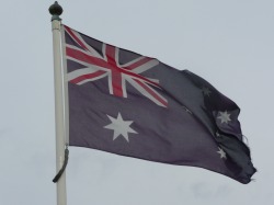
Australian flag flying at VC Corner, Fomelles.
Day 10
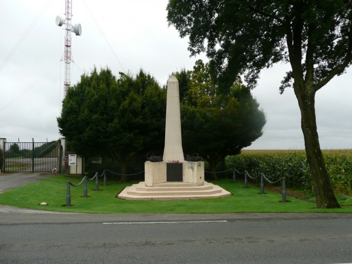
A long drive today from Belgium to Normandy, France. I decided to drive through the Somme Battlefields instead of just taking the motorway all the way down and not really seeing anything interesting. The first stop was VC Corner at Fromelles. The Cobbers memorial is located approximately 2km NW of Fromelles on the road to Sailly. The memorial is built over the remains of German concrete bunkers. The CWGC cemetery is the only all Australian cemetery in France.
From here we continued the drive towards Normandy passing through Poziers. As I wrote earlier my mum’s uncle won a VC here so we had a look at the windmill site and then drove on.
We took a bit of a round-a-bout route to get to our campsite which was the Chateau Mantragny located just east of Bayeux. The reason for his was to take in a few side sites. The first was at Foy-de-Montgommery. It is here that Rommel’s staff car was strafed by an Allied fighter and he was wounded. His driver lost his arm to a 20mm cannon hit. The site is easy to find as there is an estate gatehouse that his officers dragged him into.
Next stop was just down the road at Vimoutiers where there is a Tiger Tank. Another rare Panzer with not many surviving the war.
The next few stops were Mont Ormel and Saint-Lambert-sur-Dive. All these towns and area’s were key battle locations in the battle of the Falaise Gap when the Germans began their retreat from Normandy. The French courty side, like in the area of the Somme, is very green and picutersque and it is hard to imagine that this was the scene of great devastation during WWI and WWII. On the WWII page of this site you can see ‘Then and Now’ comparisons of the Corridor of Death. The Corridor of Death was one of the few areas where there was ford across the River Dives. Tens of thousands of Germans lost their lives to Allied artillery and airpower in this small laneway. Mont Ormel is a hill with a commanding view of the surrounding countryside. This hill was held by a Polish tank battalion. From the hill top they could observe and call in artillery and airstrikes on the retreating Germans. They knocked back repeated and determined attacks by Waffen SS troops whi were attempting to dislodge them from the hill.
We arrived at the beautiful French Chateau at Mantragny late in the afternoon and had dinner at the restaurant there. I had a steak for dinner and can tell you that Australia has the best steaks in the world.
Photographs:
1. Cobbers memorial at Fromelles.
2. German bunker.
3. Close-up of statue.
4. This German bunker is located a short distance from Fromelles.. Adolf HItler is supposed to have spent time there in WWI.
5. Memorial at Poziers.
6. Site of Windmill at Poziers.
7. Sign on main road through Poziers.
8. Liam holding onto the track of the Tiger Tank and waving to Mum and Dad.
9. Dad and Liam on the Tiger Tank.
10. Liam in his car seat.
11. View from Mont Ormel.
12. Liam and Dad at Polish M8 Greyhound on Mont Ormel.
13. Mum and Liam in the Corridor of Death at the ford on the River Dives.
14. Mont Ormel Polish memorial.
15. Dad and Liam. Liam is poking his tongue out at the photographer...Mum.


Day 11 and 12 - 04/09/2008 to 05/09/2008 - France.
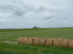
Hay in a field with Mont Saint-Michel in the middle background.
Day 11 and 12
This morning was devoted to a drive to Mont Saint-Michel. We did this via Villers Bocage where legendary German Ttank ace Michael Wittmann fought his almost lone battle against the 7th Armoured Division “The Desert Rats”. We went to a supermarket and got Liam some shoes and also some groceries. I went for a walk and found the sites from the famous german war photos of the Wittmann battle.
We then drove to Mont Saint-Michel, about 120km one way. The Abbey is on the border of Normandy and Brittany on the coast and is a UNESCO world heritage site. The worship of Saint Michel started here in 708 and the Benedictine monks started to build the Abbey in the 10th century.
The Abbey is connected to the mainland via a causeway. On low tide you can walk there without usinfg the causeway although the tide changes very quickly. The amount of people here was amazing. The car park is huge and there is even a RV site but I think from memory it was subject to the tides which are some of the strongest in Europe. The place was packed and it reminded me of the tiny streets of Venice as people teemed everywhere. As with most places in Europe when you have a one year old in a stroller you are at a disadvantage. There are stairs everywhere. We had something to eat and decided we had seen enough and left.
The afternoon was devoted to driving around the Contintan Peninsula looking at the various sites where the 101st and 82nd Airborne fought there battle on the night before D-day, on D-day and after. Tied off the day with a visit to Utah Beach. Utah Beach still has some beach obstacles and barbed wire on the high tide mark.
The second full day in Normandy started with a trip to La Cambe German War cemetery. A very beautiful but sad cemetery with a lot of unknown graves marked simply “Zwei Deutsche Soldaten” “Two German Soldiers”. Ponte Du Hoc and Omaha Beach (US) were next including the famous Coleville-sur-Mer US cemtery. After visiting the beaches we headed to the Orne River Canal where the British Airborne landed the night before D-day and captured the bridges over the canals. We went to the Merville Gun Battery, captured by British Airborne troops who suffered heavy casualties and then to Café Gondre which is owned by the same family as owned it in 1944. The café is a British Airborne monument, museum, meeting place all rolled into one. We had a cup of tea with an elderly British D-day veteran and his family. It was a rainy old day but quite enjoyable. On the way back to the Chateau we visited Arromanches, Sword Beach (British), Juno Beach (Canadian) and finally Gold Beach (British).
There you have it. We saw most of the sites in two full days of driving around. I had a Major and Mrs Holts map of the sites the TomTom to get us around and had done extensive research into what to se and the best order to fit it all in to the two days. We probably say 95% of the things we wanted to and although some were quite rushed, Like Pointe-du-Hoc and the US cemetery at Colville-sur-Mer but we were still happy.
It is interesting to note that a lot of houses, shops and farms fly the "Stars and Stripes". Although good for tourism you get the feel that in this part of France the people appreciate the sacrifice.
In the WWII segment of the site I will provide more detail and photographs of the next couple of days touring the Normandy battlefields.
Photographs:
1. Mont Saint-Michel
2. Causeway and Mont Saint Michel
3. Streets of Mont Saint Michel
4. Deam Mans Corner Museum. Place got its name due to a dead US soldier in a tank at the location for several days in 1944.
5. Church as St Mere Eglise. The parachute can be seen on the steeple.
6. Stained glass wondow depicting Airborne soldiers in St Mere Eglise church.
7. Bunker at Azeville Gun Battery.
8. Obstacles on Utah Beach.
9. Utah Beach.
10. Pegasus Bridge over the Orne River Canal.
11. Cafe Gondre at Pegasus Bridge.
12. Juno Beach. The house in the picture stood in 1944 and is now a museum dedicated to the Canadians.
13. Mulberry, artifical harbor, at Arromanches.
14. Intact 150mm gun of the Longues-sur-Mer battery. Silenced by a lucky hit from HMS Ajax afte causing much damage.
15. Monument at Colleville-sur-Mer Omaha Beach US War Cmetery.
16. US war graves ar Colleville-sur-Mer.
17. German war cemetery at La Cambe.
18. German war grave contaning two unknown soldiers.


Day 13 - 06/09/2008 - France and Belgium.
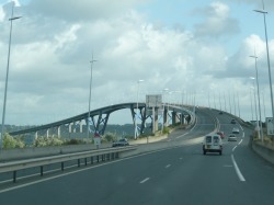
Bridge in France north of Caen.
Day 13
We are now driving back to Belgium to the city of Brugge. We travel via motorways until we near Dieppe and stop in to go the Shopping Centre and buy some food for lunch. Then down to the waterfront where the Canadians cam ashore during Operation Jubilee in 1942. This operation was designed to test how a seaborne invasion would go against a port. Not too well either with large losses to dead, wounded and captured for the Canadians. There was some sort of a fair on and parking was scarce. Jakki squeezed the camper into a spot made for a mini minor. We had sandwiches with the food we bought at the supermarket and I walked to the Canadian Memorial in a nearby park and took some photo’s of the beach front. Dieppe was eventually liberated by the Canadians and all the street names have something to do with Canada.
From here to Dunkirk. A very busy town and I was looking for the evacuation beaches of Operation Dynamo. Unable to find anything interesting although there was a small museum and the owner gave us some photographs of the local memorials.
A long drive now through the rain to Brugge in Belgium. We walked to a supermarket from the campsite and bought some meat for dinner. I bought a Belgian beer gift pack of six different types of Belgian beer. Jakki had chicken and I had a pretty good steak cooked in the camper.
Photographs:
1. Dieppe Castle.
2. The cliffs at the end of the beach with Jakki having a look.
3. Dieppe Beach.
4. Change rooms on the beach.
5. A bit out of place this building.
6.


